
Business Details
39 Years
experience
Professional Land Surveying Services in NC & SC
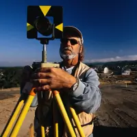
Established in 1987, GPA Professional Land Surveyors has built a reputation for excellence and integrity in serving clients across North and South Carolina. Our team of licensed professionals combines decades of experience with advanced technologies like robotic instruments, GPS, and industry-leading software to deliver precise land surveying solutions. We specialize in boundary surveys, ALTA/NSPS land title surveys, construction staking, and topographic mapping, supporting real estate professionals, attorneys, engineers, and land developers. Our commitment to personalized service ensures each client receives tailored solutions that align with their unique project requirements. With offices strategically located in Charleston, Charlotte, Fort Mill, and Raleigh, we maintain a one-source approach that streamlines processes and reduces costs.Our deadline-driven methodology guarantees timely delivery without compromising accuracy, making us a trusted partner for complex surveying challenges. From initial design phases to final as-built documentation, we provide comprehensive support that forms the foundation for successful infrastructure development. Our staff holds degrees in land surveying and civil engineering technology, ensuring technical expertise meets practical application. By fostering direct relationships between field crews and clients, we maintain transparency and accountability throughout every project lifecycle. This client-centric philosophy, combined with our deep understanding of municipal requirements, enables us to consistently exceed expectations while maintaining cost efficiency.

Services
Boundary Surveys
ALTA Surveys
GPS Services
Construction Staking
Topographic Mapping
Flood Certifications
As-Built Surveys
Land Development Surveys
Deed Research
Infrastructure Surveys
Details
- Year established: 1987
Highlights and features
- We have over 35 years of experience in professional land surveying since 1987
- Our staff maintains active licenses in both North and South Carolina
- We utilize the latest Autodesk and Carlson software for precise calculations
- Our deadline-driven approach ensures timely delivery for critical projects
- We provide direct field crew relationships for consistent project execution
Services
Boundary Surveys
Our boundary surveys establish precise property lines using historical deed research and modern GPS technology. We identify easements, encroachments, and legal descriptions to prevent disputes. Clients receive detailed plat maps that meet state-specific filing requirements for real estate transactions and development projects.
Construction Staking
We provide accurate construction staking for residential, commercial, and infrastructure projects. Our crews mark building corners, utilities, and grading points using robotic total stations. This ensures proper alignment with design plans and minimizes costly field adjustments during development phases.
Topographic Mapping
Our topographic surveys capture natural and man-made features using 3D laser scanning and GPS. The resulting detailed elevation models support drainage analysis, site planning, and engineering design. We deliver digital deliverables compatible with CAD and GIS platforms for seamless project integration.
ALTA Surveys
We conduct ALTA/NSPS land title surveys meeting American Land Title Association standards. These comprehensive boundary surveys include improvements, utilities, and zoning information for commercial real estate transactions. Our work satisfies lender requirements and reduces title insurance risks through meticulous documentation.
As-Built Surveys
Our as-built surveys document actual construction locations using robotic field measurements. We compare final conditions to design plans for municipal approvals and facility management. Clients receive accurate record drawings that reflect all field changes made during construction projects.
Questions
What geographic areas do you serve?
We provide land surveying services throughout North Carolina and South Carolina, with offices in Charleston, Charlotte, Fort Mill, and Raleigh.
How quickly can you complete a survey?
Our deadline-driven approach typically completes standard boundary surveys within 5-7 business days, with expedited options available for urgent projects.
Are your surveyors licensed?
All our field crews and project managers maintain active professional licenses in both North Carolina and South Carolina.
What technologies do you use?
We utilize robotic total stations, GPS systems, 3D laser scanners, and the latest Autodesk and Carlson software for precise data collection and mapping.
Do you work with engineering firms?
Yes, we collaborate with engineers and architects to provide accurate base mapping, construction staking, and as-built documentation for development projects.